News & Updates
September 2024 Community Forest Update
Posted September 19, 2024There are small Cedar logs from 3″ – 11″ in diameter and 8′ up to 26′ long available for sale in the community forest. Ideal for a large pole barns, woodsheds, or fencing projects, there is a fairly a large selection to choose from. Contact Mark Lombard for details at misterlombard@gmail.com.
Wildfire risk reduction (WRR) work will be getting under way in the Coulter Bay and Squirrel Cove areas of the community forest starting in October. See the previous post on this web page for details. There will be woodchips and firewood available over the winder from both projects and details will be posted once the projects are nearing completion.
There will be public tours of both sites of the risk reduction projects in October, as well as in areas where plans are being developed for shelterwood (selective) harvests in the Coulter Bay and Larsens Meadow Areas.
9:30am Sunday October 6, Coulter Bay Logging Road – 2024 Wildfire Risk Reduction and 2025 shelterwood harvest plans
9:30am Saturday October 12, Squirrel Cove Logging Road at Yellow Gate – 2024 wildfire risk reduction project
9:30am Saturday October 19, Larsens Meadow Road – 2025 Shelterwood Harvest Plans and Future wildfire risk reduction project.
No plans harvest plans have been finalized or laid out as of yet and are still open to ongoing public input, and no time frame has been established but will be based on weather and log market conditions.
The Cortes Community Forest Cooperative (CCFC) will host its annual general meeting on October 9 at 7pm at Mansons Hall. The CCFC is a 50 percent partner in the Cortes Forestry General Partnership which along with the Klaboose First Nation holds the license for the Cortes Island Community Forest.
2024/2025 Fall/Winter Wildfire Risk Reduction Work
Posted August 20, 2024The CFGP is planning to complete two wildfire risk reduction projects in the Community Forest starting in October of this year and expect the work to be completed by March 2025.
The first project is to removed the small dead stems and small Hemlock under 6″ in diameter in the area along the western boundary of the community forest in the Coulter Bay Neighbourhood. The area is 150 wide and comprises 9.8 hectares. The fine fuels will also be removed either by chipping , or by burning where chipping isn’t accessible. All the remaining stems will also be pruned up to 3 meters in order to remove the ladder fuels.
The second project is in the Squirrel Cover Area of the community forest, in the overgrown 3rd growth plantation along both sides of the logging road starting approximately 500 meters from the main road. The treatment will be the same, primarily targeting the small dead and dying hemlock that have overgrown the planted Fir and Cedar.
The two projects have been identified as priorities in the 2020 Community Wildfire Protection Plan, and prescriptions were completed for those projects in 2021. The prescriptions are available here:
CARRINGTON FMP Prescription 2021_DRAFT__AUG25_2021
SQUIRREL COVE FMP Prescription 2021_DRAFT__AUG25_2021
For more information any time, contact Mark Lombard at misterlombard@gmail.com
Community Forest Public Meeting May 30
Posted May 27, 2024The CFGP will host a public meeting on Thursday May 30, 2024 from 6:30 – 8:30 at the Gorge Hall. This will be an opportunity to hear about activities in the community forest over the past year, as well as plans for the upcoming five year period.
Cortes Fire Chief Eli McKenty will start the meeting with a short presentation on his takeaways from the Wildfire Resiliency and Training Summit he attended in Prince George in April.
The meeting will provide an opportunity for people to ask questions and have a discussion about the Community Forest and its work on the island.
We look forward to seeing you there.
Please visit the most recent news and updates as well as documents and maps pages for a detailed description of the planning currently under way in the community forest. There is also a link here for the most recent five year planning map:
THLB Overview map 2017-2022 & 2024 – 2028v2
Community Firewood Day Saturday May 11, 2024
Posted May 1, 2024The community forest will host a community firewood day on Saturday May 11 starting at 10am.
If you know a senior or someone else in need, please contact Mark Lombard by email at misterlombard@gmail.com to add their name to the list for a free pickup load of firewood.
If you would like to volunteer a pickup truck to make deliveries or if you would like to come out and help load, please contact Mark to add your name to the list. All volunteers will get a load of firewood as well.
The meeting place will be at the community forest logging road across and just down from the Main Road highway maintenance yard at 10:00 am, May 11.
April 2024 Update, May 30th Public Meeting
Posted April 17, 2024The CFGP will host a public meeting on Thursday May 30, 2024 from 6:30 – 8:30 at the Gorge Hall. This will be an opportunity to hear about activities in the community forest over the past year, as well as plans for the upcoming five year period. The meeting will also be an opportunity for people to ask questions and have a discussion.
Road building work in the Gorge Harbour Area of the community forest is now completed and the saw logs have been delivered to local mills. There will be a community firewood day sometime in May to distribute the firewood from the project to seniors and people in need. Stay tuned for more details once a date is confirmed.
There will be a public tour in the Green Mountain Area of the community forest on Saturday April 20 from 10am – noon, meeting at the entrance to Green Mountain Road. For a map of that shows this area, along with all areas under consideration for harvest activities over the next five years click here:
THLB Overview map DRAFT 2024 – 2028e.
February/March 2024 Update
Posted February 28, 2024Spring tree planting and silviculture work will get under way in the community forest around mid-March. Block GH1 that was harvested as a firebreak in the Gorge Harbour/Anvil Lake Area during spring of 2023 will be planted, along with some fill planting in blocks GM1 & VON1. All of the seedlings that have been planted to date will also be tended.
Prior to planting block GH1 the road will be decommissioned and the leftover coarse woody debris along the road will be spread out and cleaned up. The rock from the road surface will be recycled further up the main road.
A second leg of road building in the area is planned for early 2024 continuing on from the first leg that was completed in the fall of 2022. This second leg of road is the next step in the plan to build road access and implement a wildfire mitigation treatment for the area as indicated a priority in the 2020 Community Wildfire Protection plan. The second leg of road that will be built in early 2024 is shown in grey on the following map:
GH Mainline Road Construction Map 20220907
This second leg of road will end just north of the wetland and will include a turnaround suitable for fire trucks and is the only activity planned in the area for the next couple of years. The community forest has orders from local mill for sawlogs this spring and all the higher quality logs from the road building will go to supply those order, while the lower grade logs will go into firewood for a spring community firewood day.
In the longer term, the draft plan is to eventually plant Alder at the western end of the wetland in an area infected with mistletoe Hemlock in order to create a second firebreak. The basic idea is to take advantage of the opening created by the wetland, and plant a deciduous Alder patch that will together act as a natural firebreak.
That project is only in the conceptual phase at this point, and would take place at some point a few years in the future. No date has been set for that project and there will be time for further community input. See the map below for details of the area under consideration, shown as block GH2:
Five Year Plan Next Steps:
The CFGP is planning to host three public tours in areas currently under consideration for harvest operations in the upcoming five year plan. In order of priority, the Larsens Meadow Project will be first as there is a directive from the province to let in more light to the areas harvested in 2015 in order for the seedlings to reach free to grow status. This project will likely take place in early 2025, with the potential for some road work in the fall of this year.
After Larsens Meadow, the next harvest priority will likely be in the Carrington Coulter Bay Area given that the area is a priority for wildfire mitigation treatment in the Community Wildfire Protection Plan, and the harvest will tie in with the proposed treatment.
The third tour will be be in the Green Mountain Area as it a new area under consideration for operations, although the harvest in that area will likely be a bit later in the next five year cycle.
Saturday March 23 at 10am @Larsens Meadow – meet on Larsens Meadow Road
Saturday March 30 at 10am @ Coulter Bay – meet at the entrance to the new community forest road in Coulter Bay.
Saturday April 20 at 10am @ Green Mountain – meet at Green Mountain Road
The map below shows these and the other two areas under consideration for harvesting in the next five year cycle:
THLB Overview map DRAFT 2024 – 2028
Once these initial public tours are completed, the CFGP will host a public meeting to discuss ongoing planning, operations, and next steps, likely in May.
Regarding the five year plan, the operations planning map above is the primary 5 year plan going forward. More details will be incorporated following input from the upcoming public tours, and detailed engineering will be completed for each area as the time comes to work on each project. The GFGP does not expect that the detailed engineering will be significantly different than the areas shown in the projection, given that the planning is focused on staying away from sensitive areas and designed to allow for selective harvesting systems.
2024 Wildfire Planning Update
PostedThe CFGP is continuing work on implementing the recommendations from the 2020 Community Wildfire Protection Plan specific to areas within the Community Forest Landbase. See the map below for details:
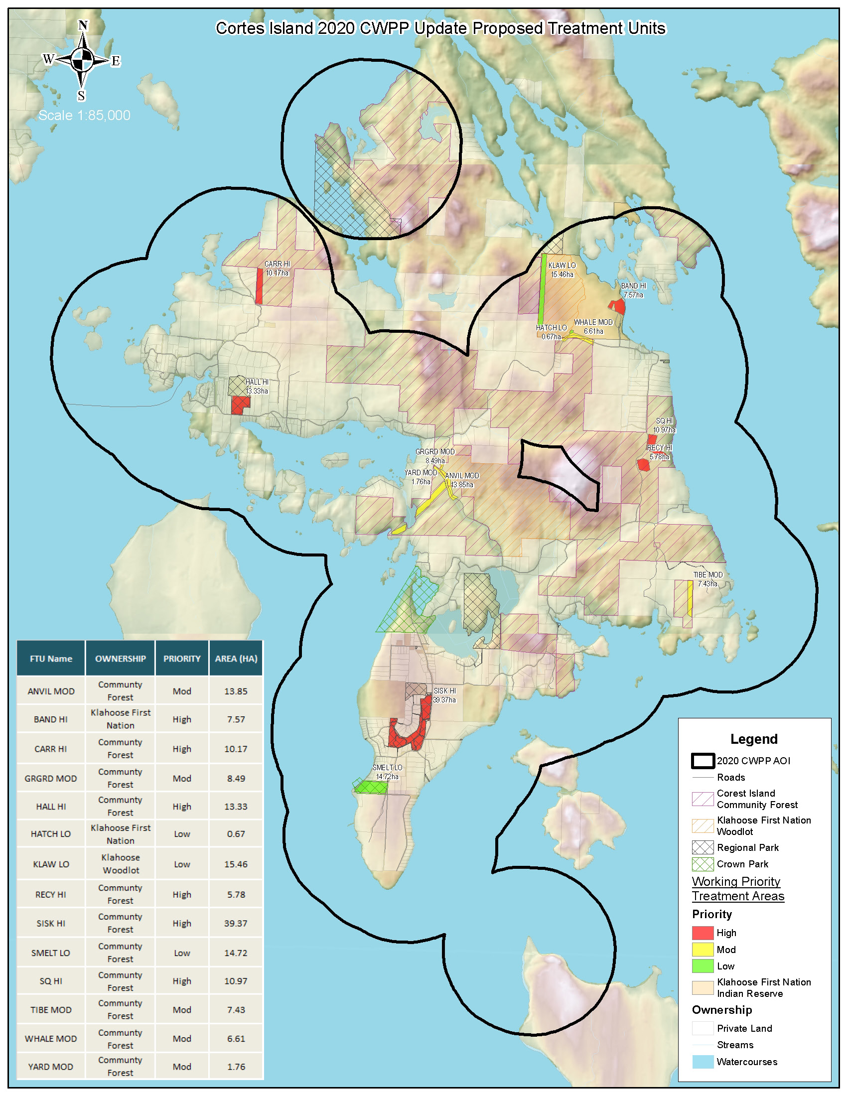
Those recommendations include building road access to specific areas crossing the community forest, along with thinning along the western boundary in the Carringto/Coulter Bay Area and in the overgrown 3rd growth blocks in the Squirrel Cove Area of the Community Forest. The prescriptions for these are available here:
CarrHi_Boundary
CARRINGTON FMP Prescription 2021_DRAFT__AUG25_2021
SQ_HI
SQUIRREL COVE FMP Prescription 2021_DRAFT__AUG25_2021
A thinning project in the area surrounding the area surrounding the recylcing center was completed in March 2022. The map of the area is available here:
RecyHi_Boundary
RECYCLING FMP Prescription 2021_DRAFT
The plan also calls for a fire break in the Gorge Harbour/Anvil Lake area, which was partially completed in 2022 & 2023 by building initial road access in the area, and harvesting the small fire break called block GH1.
Futher road building in the area is planned for early 2024 in order to gain access, and eventually plant Alder at the western end of the wetland to the south of block GH1 in an area infected with mistletoe Hemlock. That project would take place sometime in the future and the area is shown on the maps below as block GH2.
The first map shows the next length of road to be built in early 2024, and the second map shows block GH1 which was harvested in 2023 and block GH2 which is under consideration to be planted in Alder at some as of yet undetermined time in the future.
GH Mainline Road Construction Map 20220907
Some of the wildfire risk reduction treatment work in the Carrington Bay/Carrington and Squirrel Cove Areas may be completed concurrently with harvesting in those areas as per the five year plan, depending on funding availability,
MTN Retrospective Report on Harvesting in the Community Forest
Posted June 14, 2023In the fall of 2022 a team from the Mother Tree Network completed a field study of each of the harvests to date in the Cortes Community Forest. Led by Dr. Suzanne Simard, forest ecology professor at the University of British Columbia, the Mother Tree Project brings together academia, government, forestry companies, research forests, community forests and First Nations to identify and design successful forest renewal practices.
The study objective was to examine how recent harvesting systems as well as older clearcutting and planting have affected tree carbon stocks, forest structure, regeneration, understory plant communities, and the forest floor. The draft report on the study is available here:
The community forest is continuing to work with the Mother Tree Network on the harvest plans for the upcoming five year plan. Stay tuned for opportunities to hear about this ongoing collaboration, likely later on in the fall of 2023.
Five Year Plan Update
Posted May 2, 2023The CFGP will host a public meeting on Thursday May 11, 2023 at 6:30 pm at the Klahoose Multipurpose Hall to launch the public consultation process for updating the five year.
There will be an overview of the activities in the community forest over the past five years, followed by a presentation and discussion of the plans under consideration for the upcoming five years.
A preliminary map showing the areas under consideration for operations over the next five years is available here:
THLB Overview map DRAFT 2024 – 2028
This map is not a final plan and areas may be added or removed based on ongoing discussion with the board and the public. The purple areas are the areas under consideration and the blue area is the a back up location in the event that other areas don’t work out. The map does not contain detailed engineering as it intended to simply show areas under consideration. In addition, more detailed conversations will be held with neighbours in each of the areas under consideration prior to more detailed planning.
Free Use Firewood Permits April & May 2023
Posted April 10, 2023Work on the firebreak in the Gorge Harbour Area of the Community Forest is now completed and the area remains open for people to go out and collect free firewood for personal in the block. The location is up the new logging road across and just down from the highway shed on Gorge Harbour Road.
The firewood is free and people are allowed two average size pickup loads per household.
Please do not buck up any downed trees along the road and only take wood that is at roadside in the block.
There is a small about of wood already bucked into rounds that would be available for people without a chainsaw, but the majority of the wood is full length at roadside and needs to be bucked.
If you don’t have a chainsaw or pickup you can organize with someone else to go and collect a load or two.
Provincial regulations require that people download and fill out a free use permit and simply keep it in the truck that is hauling your wood. Free use permits are available here:
FreeUsePermit April & May 2023 GH1
NOTE: Older drafts of the free use permits may be old, if you’ve already downloaded one but just cross out the date and write in the new one.